


WSDOT
3.71.15K Reviews
App Specs
- Version
- 6.41.0
- Updated On
- License
- Free
- Downloads
- 500,000+
- Developer
- WSDOT
- Categories
- Travel & Local
- Platform
- Android
Screenshots
 Analysis by AppCompare
When I want a quick picture of travel conditions in Washington, I would rather begin with the state transportation agency’s own app than piece together scattered reports from several services. WSDOT is the official travel-information app from the Washington State Department of Transportation, and its focus is refreshingly narrow: helping people understand what is happening on the state’s roads and travel routes.
That narrow purpose is also the key to using it well. This is not an all-purpose navigation replacement, and it is not designed to plan every detail of a holiday. I see it as a preparation and decision-making tool. Before leaving, I can check the situation along a route; during a trip, I can use it to reassess whether a delay, closure, or changing condition should affect my plans. The app is free, rated for Everyone, and belongs in the Travel & Local category.
My overall impression is positive, with an important qualification: the value depends on checking the right information before assuming the app is at fault. A traffic-information app can feel unhelpful when a route is unclear, a report has changed, or a phone is showing stale content. In practice, a few setup habits make the experience much more dependable.
Getting past the first points of friction
I’ve found that the easiest way to make WSDOT useful is to treat each check as a small decision, not a search for a perfect prediction. I first identify which part of my journey could change the plan, then compare that information with what I need to do next. That habit keeps the app’s focused role clear and sets up a practical look at how it fits alongside everyday navigation tools.
Why the first check can feel less obvious than expected
The most common mistake is opening WSDOT with a destination in mind but without deciding what kind of information is needed. “How is my trip?” can mean several different things: a current slowdown, a road closure, a pass condition, a ferry issue, or a planned work zone. Those are not interchangeable questions. If I look only for a general traffic picture, I may miss the specific event that matters most to my journey.
I find it more useful to start with a route outline rather than a street address. I identify the main highways, bridges, passes, or water crossings involved, then inspect the relevant information in that order. This avoids a common dead end where someone expects the app to behave exactly like a turn-by-turn navigation service and becomes frustrated when the most useful answer is presented as transportation information instead of a complete route plan.
Another source of confusion is timing. A traffic report is a snapshot of a changing situation, not a promise about what the road will look like when I arrive. If I check too early and never look again, the information can become less useful even though the app itself is working normally. For a trip with a fixed departure time, I prefer two checks: one while preparing and another shortly before leaving.
Worth Reading Before You Choose

EA SPORTS FC Mobile 26 Is a Bigger Football Game, but It Takes Time

Flipboard Shows What News Apps Must Do Beyond the Feed

Switching to Android Auto Means Rethinking Your Driving Routine

Google Calendar Makes a Crowded Week Easier to Manage

Ludo King Makes the Most of the Minutes Between Plans

Baby Panda World Brings Quick Play to Modern Phones, but Its Game Library Feels Busy
A simple setup routine before relying on it
My first setup check is basic but worthwhile: I make sure the app is installed from the correct publisher, WSDOT, and that the phone meets the stated minimum operating-system requirement of Android 6.0 or a later release. The current version is 6.41.0, so keeping the app current is sensible when the phone offers an update. I would not treat an older phone as automatically unusable, but an outdated system or app can create avoidable loading and display problems.
Next, I check the phone’s connection before judging the information. If the device is moving between weak cellular coverage areas, switching networks, or operating in a location with poor reception, a page may load slowly or appear incomplete. I usually wait for the screen to finish loading instead of immediately tapping through several sections. Repeated taps during a slow connection can make it difficult to tell whether the app ignored an action or is still working.
I also prepare the route mentally before opening the app. For a long drive, I write down the major corridors and decision points in a note, because that gives me a practical checklist. This is especially useful when the trip includes several highways. Rather than browsing randomly, I can verify each important segment and then close the app before driving. The safest workflow is to use WSDOT for preparation and informed decisions, not for constant phone handling behind the wheel.
For a passenger checking conditions during a journey, I would still use the same approach. The passenger can compare the planned route with current reports, while the driver remains focused on the road. If I am driving alone, I stop in a safe place before checking anything. The app’s usefulness is not a reason to turn a travel-information check into a distraction.
What to do when information seems missing
When a result does not appear, I first ask whether I am looking at the correct part of the trip. A road issue may affect one corridor while the route I chose uses another. I then refresh my understanding of the route and try again, rather than assuming that an empty-looking view means the entire state is clear.
It is also worth distinguishing between “no useful report for this exact moment” and “the app failed.” Transportation conditions are uneven: one part of a journey can be moving normally while another has a significant problem. A broad search may therefore feel vague, while a focused check of the route’s key sections gives a clearer answer.
If the app opens but content does not update, I use a safe, general sequence: confirm the connection, close and reopen the app, and try again after moving to a place with a stronger signal. I avoid repeatedly changing phone settings while standing near traffic or preparing to depart. If the problem continues, I use another trusted source for immediate safety decisions and treat the app as unavailable for that moment rather than taking a risk.
Recovering a trip when conditions change
The most useful way I have found to use an official traffic app is as part of a recovery plan. Suppose I am leaving for a weekend drive and discover that one major segment is disrupted. I do not immediately choose the first alternative suggested by a general mapping app. I first identify where the problem begins, whether it affects the entire route or only a section, and whether the alternative would introduce another major crossing or high-risk segment.
This matters because a mapping service and WSDOT answer different questions. A mapping app is usually better at calculating a route from one address to another and estimating travel time. WSDOT is more valuable when I need official context about state transportation conditions. I use the map for geometry and the state source for situational awareness, then make the decision myself.
A practical recovery workflow looks like this:
I note the affected road or travel segment instead of reacting only to the destination’s estimated arrival time.
I check whether my planned route has another important bottleneck farther ahead.
I compare the alternative with the original plan, including the possibility that a longer route may be less stressful than repeated uncertainty.
I tell anyone expecting me that the plan changed before I start moving again.
This approach prevents a subtle mistake: treating a route change as solved merely because a navigation app draws a different line. A different line can still pass through conditions I have not checked. WSDOT is particularly useful here because it encourages me to think in terms of the state’s transportation network rather than only the shortest path between two points.
Using it for more than an ordinary commute
For a daily commute, I would not necessarily open the app every morning if my route is stable and conditions are routine. I would use it selectively on days when weather, construction, an event, or a major disruption could change the decision. The less obvious benefit is that the app can help me decide whether I should leave earlier, delay the trip, or choose a different corridor before I am already trapped in a queue.
For a longer trip, I would check the route in sections. A journey across Washington can involve very different road environments, and a single general impression is not enough. I might check the first urban section, the main intercity highway, and any pass or crossing that could determine whether the plan remains practical. This segmented method is more reliable than searching for one perfect answer.
It is also helpful for people who regularly drive someone else’s vehicle or travel with family members. I can check conditions before the group leaves, explain the likely decision points, and agree on what would trigger a change of plan. That reduces the temptation to make rushed decisions from the driver’s seat.
When the problem is probably outside the app
Not every disappointing result is an application failure. A phone can have a weak connection, the operating system can be too old for a smooth experience, or the user can be checking the wrong segment. The transportation situation itself may also have changed between the time of the report and the time I reach the road. These are normal complications of live travel information.
I am careful with expectations around precision. An official source can provide valuable information without predicting exactly how long my personal trip will take. Traffic builds and clears, incidents develop, and local conditions can affect the experience between checks. For that reason, I use the app to support judgment rather than to promise an exact arrival time.
There is another limitation worth stating clearly: WSDOT is not the right single tool for every travel question. If I need detailed walking directions, a restaurant search, a complete itinerary, or door-to-door navigation, I would use a general map or travel-planning app alongside it. If I need broader information outside Washington’s transportation system, I would look for the relevant local authority. The app is strongest when the question is specifically about Washington travel conditions.
That specialization is not a weakness for the right audience. In fact, it is why I trust it more for state-road preparation than a generic app that combines many data sources into one simplified screen. The trade-off is that I have to do a little more interpretation. I get official context, but I should not expect the app to make every travel decision for me.
Who should install it
I would recommend WSDOT to Washington residents, commuters who regularly use state routes, road-trip travelers crossing the state, and anyone who wants an official source to consult before setting out. It is also useful for passengers who help monitor changing conditions during a long drive. Since it is free and suitable for Everyone, there is little practical barrier to trying it before an important journey.
The app has reached over 500 thousand installs and holds a 3.7 average from around 3.8 thousand ratings, which suggests a substantial user base but also a mixed experience rather than universal approval. I read that as a reason to use it thoughtfully, not as a reason to dismiss it. Traffic apps are judged during stressful moments, and a slow connection or unclear route can heavily influence how people feel about them.
I would skip it as my main travel tool if I rarely travel in Washington, if I want a polished door-to-door navigation experience, or if I expect one app to handle every part of a vacation. I would also avoid relying on it alone when a trip involves urgent safety decisions. In those cases, I want current local guidance and sensible judgment, with the app serving as one source rather than the entire plan.
My practical verdict after using it
WSDOT is a focused, useful travel app rather than an all-purpose navigator. Its strongest role is helping me check Washington transportation conditions before I commit to a route, then reassess the plan when circumstances change. The best results come from identifying the important segments of a trip, checking them deliberately, and allowing for the fact that live information can change.
The developer, WSDOT, gives the app a clear public-service identity, and that makes it a natural companion to—not a replacement for—general mapping tools. I appreciate that distinction. A map can tell me where to go; this app helps me think about whether that route still makes sense right now.
My final recommendation is straightforward: install it if Washington road conditions affect your regular travel, but build a sensible routine around it. Check the connection, use the current version when possible, review the route in sections, and never interact with the phone while driving. With those habits, WSDOT is a practical second opinion for Washington travel decisions, especially when a normal commute suddenly becomes a question of timing, route choice, or whether to leave at all.
Released on April 2, 2010, it has had plenty of time to establish its place as a dedicated state travel resource. I would not choose it for entertainment or broad trip discovery, but that is not what it needs to be. For the specific job of checking official Washington travel information, it earns a place on my phone and in my pre-trip routine.
Pros
- Provides real-time Washington traffic and road condition updates.
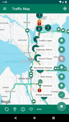
- Offers live camera views to check routes before traveling.
- Includes alerts about collisions
- closures
- construction
- and weather.
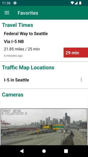
- Helps drivers plan trips with current travel-time information.
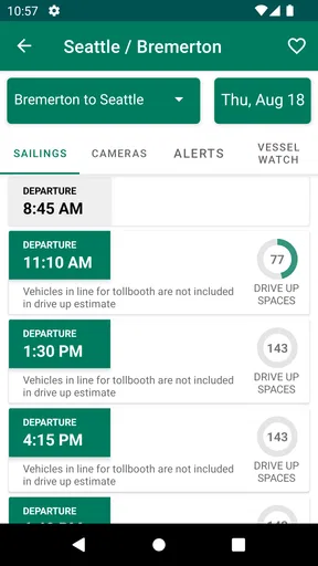
- Useful for checking ferry schedules and transportation disruptions.
Cons
- Coverage is mainly limited to Washington State roads and services.
- Some camera feeds may load slowly or be temporarily unavailable.
- Frequent alerts can feel overwhelming during major travel periods.
- Information may change quickly and require occasional manual refreshing.
- The interface can feel less intuitive on smaller phone screens.
FAQs for WSDOT
What is the WSDOT app used for?
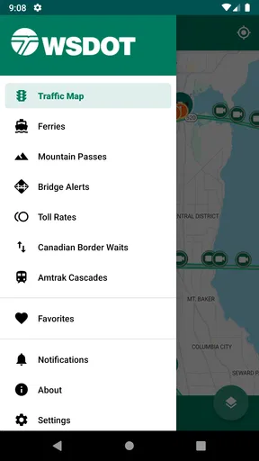
The WSDOT app is designed to help travelers in Washington State plan safer, more informed journeys. It provides access to traffic conditions, highway incidents, construction updates, mountain pass information, ferry schedules, ferry alerts, and selected camera views. After testing the main sections, I found it most useful before and during a trip, especially when checking whether weather, congestion, or roadwork could affect a planned route.
Does the WSDOT app provide real-time traffic and road condition information?
WSDOT offers frequently updated information about traffic incidents, closures, construction zones, and road conditions across Washington. Depending on the feature and location, updates may come from transportation reports, sensors, cameras, or official notices, so they should not be treated as an exact second-by-second guarantee. I recommend checking the app shortly before leaving and again during longer journeys, particularly in winter or during severe weather.
Can I use WSDOT to check Washington State ferry schedules and alerts?
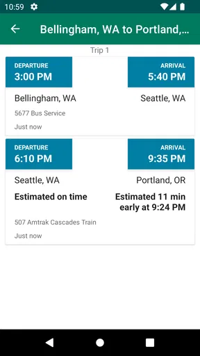
Yes. One of the app’s most useful features is access to Washington State Ferries information, including sailing schedules, service alerts, terminal details, and, where available, estimated waits or related travel updates. Ferry operations can change because of weather, mechanical problems, staffing, or heavy demand, so checking the latest alert before driving to a terminal is important. The app is helpful, but it does not replace official announcements.
Does the WSDOT app show mountain pass conditions and highway cameras?
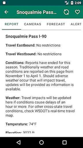
The app includes information that can help users evaluate mountain pass and highway travel, such as pass reports, weather-related conditions, restrictions, closures, and camera views in supported areas. These tools are especially valuable when crossing routes affected by snow, ice, fog, or chain requirements. Camera images may not update continuously, and conditions can change quickly, so drivers should combine the app’s information with official warnings and safe driving decisions.
Is the WSDOT app free, and does it require an internet connection?
The WSDOT app is generally available as a free download, although normal mobile data charges may apply depending on your carrier and plan. Most live features, including traffic reports, ferry updates, alerts, and camera images, require an internet connection to retrieve current information. Some previously loaded content may remain visible briefly, but users should not depend on offline access for accurate road conditions or emergency travel decisions.


